
FAQ: General
UGRF aligns with the International Terrestrial Reference Frame (ITRF), ensuring global compatibility and consistency in spatial data. It supports applications like surveying, construction, land management, and disaster monitoring by providing high-precision positioning, standardizing geospatial data, and enhancing decision-making.
UGRF is aligned to ITRF2005@2010.0 through the measurement of 9 Zero-order points in 2010, tying them to ITRF stations.
UGRF is aligned to ITRF2005@2010.0 through the measurement of 9 Zero-order points in 2010, tying them to ITRF stations.
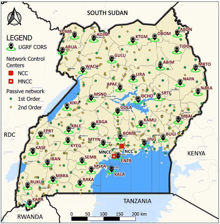
The Uganda Geodetic Reference Framework (UGRF) is a modern geodetic infrastructure providing accurate and reliable spatial data for geospatial activities in Uganda. It comprises a network of 40 Continuously Operating Reference Stations (CORS), 426 passive control points, and a transformation model for coordinates transformation.
CORS are permanent GNSS stations that collect satellite signals 24/7. They provide real-time and post-processed positioning data, enabling users to achieve high-precision positioning for surveying, mapping, and geospatial applications.
CORS stations eliminate the need for traditional base stations, saving time and resources while improving data reliability.
CORS stations eliminate the need for traditional base stations, saving time and resources while improving data reliability.
The UGRF network currently comprises 40 active Continuously Operating Reference Stations (CORS) strategically distributed across Uganda. These stations provide nationwide coverage, ensuring accurate real-time and post-processed GNSS data for geospatial applications.
Northern Uganda: Gulu, Arua, Lira, Yumbe, Adjumani, Pakwach, Apac, Kitgum, Orom, Abim, Kaabong, Kotido, Napak, Nakapiripiriti
Eastern Uganda: Bugiri, Mbale, Kamuli, Jinja, Soroti, Ochero
Western Uganda: Kabale, Rukungiri, Ibanda, Mbarara, Kasese
Central Uganda: Masaka, Sembabule, Mityana, Rakai, Bombo, Kiboga, Kalangala
The UGRF network benefits surveyors, engineers, cartographers, researchers, and other geospatial professionals. It supports projects in land management, infrastructure development, agriculture, environmental monitoring, and disaster management by providing accurate spatial data and positioning.
Major stakeholders include government agencies, private companies, academic institutions, and NGOs involved in mapping, construction, and scientific research requiring high-precision geospatial data.
Major stakeholders include government agencies, private companies, academic institutions, and NGOs involved in mapping, construction, and scientific research requiring high-precision geospatial data.
You can report issues or provide feedback by contacting our support team via ugrf.mlhud@gmail.com. Please include detailed information about the issue, such as the CORS station involved, the date and time of the problem, and any error messages you encountered.
For general feedback, share your suggestions or concerns about the services offered. Our team is committed to addressing issues promptly and improving the UGRF system based on user input.
For general feedback, share your suggestions or concerns about the services offered. Our team is committed to addressing issues promptly and improving the UGRF system based on user input.
UGRF services are primarily intended for users in Uganda, supporting local geospatial activities such as surveying, mapping, and infrastructure development.
However, some stations in the UGRF network are being integrated into the International GNSS Service (IGS) and will then be useful for the whole geodetic international community.
Regarding access to the services, most of them are accessible from outside. However, online post-processing or RTK corrections are available only for points situated inside Uganda.
Currently, UGRF services are free and accessible to all users and are expected to remain free for a significant time.
However, in the future, a fee might be introduced to cater for the maintenance and operational costs of the CORS stations, infrastructure, and other related services. This will ensure the continued reliability and sustainability of the network.
Details about the fee structure and its implementation will be shared with users in advance to allow them to plan accordingly and continue benefiting from UGRF services without interruption.
To access UGRF services and data, visit the official UGRF website at ugrf.mlhud.go.ug. Here, you can access various services, including the description cards for both CORS stations and passive control points, which provide key information about the locations and specifications of these geodetic points.